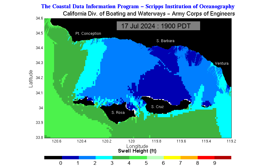
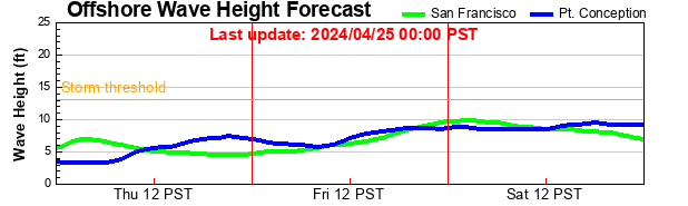
FZUS56 KLOX 182102 CWFLOX Coastal Waters Forecast for California National Weather Service Los Angeles/Oxnard CA 202 PM PDT Sun Oct 18 2026 Point Piedras Blancas to San Mateo Point CA out 60 NM including the Channel Islands National Marine Sanctuary. 202 PM PDT Sun Oct 18 2026 .Synopsis for the southern California coast and Santa Barbara Channel including the Channel Islands National Marine Sanctuary and National Park...At 20Z, or 1 PM PDT, a 1032 mb high was 1500 NM W of Point Conception and a 1013 mb low was near Santa Catalina Island with a trough of low pressure extending NW inland from the coast into northwestern CA. Looking ahead, a moderate storm system is expected to affect the coastal waters between Tuesday night and Thursday with reduced visibility in showers and a slight chance of thunderstorms.
Point Piedras Blancas to Point Sal westward out to 10 NM-
202 PM PDT Sun Oct 18 2026
TONIGHT
NW wind 10 to 20 kt. Seas 6 to 8 ft. Wave Detail: NW 3 ft at 7 seconds, NW 6 ft at 12 seconds and S 3 ft at 16 seconds. Patchy fog.
MON
NW wind 10 to 20 kt, becoming 15 to 20 kt in the afternoon. Seas 6 to 8 ft. Wave Detail: N 2 ft at 6 seconds, NW 6 ft at 12 seconds and S 3 ft at 16 seconds. Patchy fog.
MON NIGHT
NW wind 10 to 20 kt, becoming 5 to 10 kt after midnight. Seas 5 to 7 ft. Wave Detail: NW 2 ft at 6 seconds, NW 6 ft at 12 seconds and S 3 ft at 16 seconds. Patchy fog.
TUE
Light winds, becoming SW 5 to 10 kt in the afternoon. Seas 4 to 5 ft. Wave Detail: W 4 ft at 11 seconds and S 3 ft at 15 seconds. Patchy fog in the morning.
TUE NIGHT
Light winds, becoming SE 5 to 10 kt after midnight. Seas 5 to 7 ft. Wave Detail: NW 6 ft at 13 seconds and S 3 ft at 15 seconds. A chance of showers in the evening, then showers likely after midnight.
WED
SE wind 5 to 10 kt in the morning, becoming light. Seas 5 to 7 ft. Wave Detail: NW 6 ft at 12 seconds and S 3 ft at 14 seconds. Showers.
WED NIGHT
Light winds. Seas 4 to 6 ft. Wave Detail: W 5 ft at 11 seconds and S 3 ft at 14 seconds. Showers with a slight chance of tstms in the evening, then showers likely after midnight.
THU
Light winds, becoming NW 10 to 15 kt in the afternoon. Seas 3 to 5 ft. Wave Detail: W 3 ft at 10 seconds and S 3 ft at 15 seconds. A chance of showers.
THU NIGHT
NW wind 20 to 30 kt, becoming 15 to 25 kt after midnight. Seas 4 to 5 ft. Wave Detail: NW 4 ft at 5 seconds, NW 2 ft at 11 seconds and S 2 ft at 15 seconds.
FRI
N wind 10 to 15 kt, becoming NW 10 to 20 kt in the afternoon. Seas 4 to 6 ft. Wave Detail: NW 4 ft at 7 seconds, NW 2 ft at 14 seconds and S 2 ft at 15 seconds.
FRI NIGHT
NW wind 15 to 25 kt. Seas 5 to 6 ft. Wave Detail: NW 4 ft at 8 seconds, NW 5 ft at 12 seconds and S 2 ft at 16 seconds. Winds and seas higher in and near tstms.
Point Piedras Blancas to Point Sal from 10 to 60 NM-
202 PM PDT Sun Oct 18 2026
TONIGHT
NW wind 15 to 20 kt. Seas 8 to 9 ft. Wave Detail: NW 5 ft at 7 seconds, NW 7 ft at 12 seconds and S 3 ft at 16 seconds. Patchy fog.
MON
NW wind 15 to 20 kt. Seas 8 to 9 ft. Wave Detail: NW 3 ft at 6 seconds, NW 7 ft at 12 seconds and S 4 ft at 16 seconds. Patchy fog.
MON NIGHT
NW wind 10 to 15 kt, becoming 5 to 10 kt after midnight. Seas 6 to 7 ft. Wave Detail: NW 5 ft at 7 seconds, NW 6 ft at 12 seconds and S 3 ft at 16 seconds. Patchy fog.
TUE
Light winds. Seas 5 to 7 ft. Wave Detail: NW 6 ft at 14 seconds and S 3 ft at 15 seconds. Patchy fog in the morning. A slight chance of showers in the afternoon.
TUE NIGHT
Light winds. Seas 7 to 8 ft. Wave Detail: NW 7 ft at 13 seconds and S 3 ft at 15 seconds. A chance of showers in the evening, then showers after midnight.
WED
SE wind 5 to 10 kt in the morning, becoming light. Seas 7 to 8 ft. Wave Detail: NW 7 ft at 12 seconds and S 4 ft at 14 seconds. A slight chance of tstms. Showers.
WED NIGHT
Light winds. Seas 5 to 7 ft. Wave Detail: NW 5 ft at 10 seconds and S 4 ft at 14 seconds. A slight chance of tstms. Showers.
THU
N wind 5 to 10 kt, becoming NW 10 to 15 kt in the afternoon. Seas 4 to 5 ft. Wave Detail: NW 2 ft at 7 seconds, NW 4 ft at 11 seconds and S 3 ft at 15 seconds. Showers likely in the morning, then a slight chance of showers in the afternoon.
THU NIGHT
NW wind 15 to 20 kt. Seas 5 to 6 ft. Wave Detail: NW 5 ft at 7 seconds, NW 2 ft at 11 seconds and S 3 ft at 15 seconds.
FRI
NW wind 10 to 20 kt. Seas 6 to 7 ft. Wave Detail: NW 6 ft at 7 seconds, NW 3 ft at 13 seconds and S 3 ft at 15 seconds.
FRI NIGHT
NW wind 10 to 20 kt. Seas 6 to 8 ft. Wave Detail: NW 4 ft at 7 seconds, NW 7 ft at 11 seconds and S 3 ft at 16 seconds. Winds and seas higher in and near tstms.
Waters from Pt. Sal to Santa Cruz Island CA and westward 60 nm including San Miguel and Santa Rosa Islands- 202 PM PDT Sun Oct 18 2026
...SMALL CRAFT ADVISORY IN EFFECT FROM LATE TONIGHT THROUGH LATE MONDAY NIGHT...
TONIGHT
NW wind 15 to 20 kt, becoming 20 to 25 kt after midnight. Seas 6 to 9 ft. Wave Detail: NW 3 ft at 7 seconds, NW 7 ft at 12 seconds and S 3 ft at 16 seconds. Patchy fog.
MON
NW wind 20 to 25 kt. Seas 7 to 8 ft. Wave Detail: NW 3 ft at 6 seconds, NW 7 ft at 12 seconds and S 3 ft at 16 seconds. Patchy fog.
MON NIGHT
NW wind 15 to 25 kt, becoming 10 to 20 kt after midnight. Seas 6 to 8 ft. Wave Detail: NW 3 ft at 6 seconds, NW 7 ft at 12 seconds and S 3 ft at 16 seconds. Patchy fog.
TUE
W wind 10 to 15 kt, becoming SW 5 to 10 kt in the afternoon. Seas 5 to 6 ft. Wave Detail: NW 5 ft at 11 seconds and S 3 ft at 15 seconds. Patchy fog in the morning.
TUE NIGHT
Light winds, becoming SE 5 to 10 kt after midnight. Seas 6 to 8 ft. Wave Detail: NW 7 ft at 13 seconds and S 3 ft at 15 seconds. A chance of showers in the evening, then showers likely with a slight chance of tstms after midnight.
WED
S wind 5 to 10 kt. Seas 6 to 8 ft. Wave Detail: NW 7 ft at 12 seconds and S 3 ft at 14 seconds. A slight chance of tstms. Showers.
WED NIGHT
S wind 5 to 10 kt, becoming NW after midnight. Seas 5 to 7 ft. Wave Detail: NW 6 ft at 11 seconds and S 3 ft at 14 seconds. Showers with a slight chance of tstms.
THU
NW wind 5 to 10 kt, becoming 10 to 15 kt in the afternoon. Seas 4 to 5 ft. Wave Detail: NW 2 ft at 6 seconds, NW 4 ft at 10 seconds and S 3 ft at 15 seconds. Showers likely in the morning, then a chance of showers in the afternoon.
THU NIGHT
NW wind 20 to 25 kt. Seas 5 to 6 ft. Wave Detail: NW 6 ft at 7 seconds, NW 2 ft at 11 seconds and S 3 ft at 15 seconds.
FRI
NW wind 20 to 30 kt. Seas 5 to 7 ft. Wave Detail: NW 6 ft at 7 seconds, NW 3 ft at 14 seconds and S 3 ft at 17 seconds.
FRI NIGHT
NW wind 25 to 30 kt, becoming N 20 to 25 kt after midnight. Seas 6 to 8 ft. Wave Detail: NW 7 ft at 8 seconds, NW 7 ft at 12 seconds and S 3 ft at 16 seconds. Winds and seas higher in and near tstms.
Outer waters from Santa Cruz Island to San Clemente Island to 60 NM offshore including San Nicolas and Santa Barbara Islands- 202 PM PDT Sun Oct 18 2026
...SMALL CRAFT ADVISORY IN EFFECT FROM LATE TONIGHT THROUGH LATE MONDAY NIGHT...
TONIGHT
NW wind 10 to 20 kt, becoming 15 to 25 kt after midnight. Seas 6 to 8 ft. Wave Detail: NW 3 ft at 6 seconds, NW 6 ft at 12 seconds and S 3 ft at 15 seconds. Patchy fog after midnight.
MON
NW wind 15 to 25 kt. Seas 6 to 8 ft. Wave Detail: NW 2 ft at 6 seconds, NW 7 ft at 11 seconds and S 3 ft at 16 seconds.
MON NIGHT
NW wind 15 to 25 kt, becoming 10 to 20 kt after midnight. Seas 6 to 8 ft. Wave Detail: NW 4 ft at 6 seconds, NW 6 ft at 12 seconds and S 3 ft at 16 seconds. Patchy fog.
TUE
NW wind 10 to 15 kt, becoming W 5 to 10 kt in the afternoon. Seas 5 to 7 ft. Wave Detail: NW 2 ft at 5 seconds, NW 5 ft at 11 seconds and S 3 ft at 15 seconds. Patchy fog in the morning.
TUE NIGHT
Light winds. Seas 4 to 6 ft. Wave Detail: NW 5 ft at 14 seconds and S 3 ft at 14 seconds. A slight chance of showers in the evening, then a chance of showers after midnight.
WED
S wind 5 to 10 kt. Seas 5 to 7 ft. Wave Detail: NW 5 ft at 13 seconds and S 3 ft at 14 seconds. Showers in the morning, then showers with a slight chance of tstms in the afternoon.
WED NIGHT
S wind 5 to 10 kt in the evening, becoming light. Seas 4 to 6 ft. Wave Detail: W 5 ft at 11 seconds and S 3 ft at 15 seconds. Showers with a slight chance of tstms.
THU
NW wind 5 to 10 kt, becoming 10 to 15 kt in the afternoon. Seas 3 to 5 ft. Wave Detail: NW 2 ft at 4 seconds, W 4 ft at 10 seconds and S 3 ft at 15 seconds. Showers likely in the morning, then a chance of showers in the afternoon.
THU NIGHT
NW wind 15 to 25 kt, becoming 20 to 25 kt after midnight. Seas 4 to 6 ft. Wave Detail: NW 5 ft at 7 seconds, W 2 ft at 11 seconds and S 3 ft at 15 seconds.
FRI
NW wind 15 to 25 kt. Seas 5 to 7 ft. Wave Detail: NW 6 ft at 7 seconds and S 2 ft at 15 seconds.
FRI NIGHT
NW wind 15 to 25 kt. Seas 6 to 8 ft. Wave Detail: NW 6 ft at 8 seconds, NW 2 ft at 13 seconds and S 2 ft at 16 seconds. Winds and seas higher in and near tstms.
East Santa Barbara Channel from Pt. Conception to Pt. Mugu CA including Santa Cruz Island- 202 PM PDT Sun Oct 18 2026
TONIGHT
NW wind 10 to 15 kt. Seas 2 to 4 ft. Wave Detail: NW 3 ft at 7 seconds, W 3 ft at 12 seconds and S 2 ft at 16 seconds.
MON
Western Portion, NW wind 5 to 10 kt becoming W 10 to 20 kt in the afternoon. Eastern Portion, Light winds becoming W 5 to 10 kt in the afternoon. Seas 3 to 5 ft. Wave Detail: W 3 ft at 7 seconds, W 3 ft at 10 seconds and S 2 ft at 16 seconds.
MON NIGHT
NW wind 10 to 20 kt. Seas 3 to 5 ft. Wave Detail: W 4 ft at 7 seconds, W 2 ft at 12 seconds and S 2 ft at 16 seconds.
TUE
W wind 5 to 10 kt. Seas 2 to 4 ft. Wave Detail: W 3 ft at 11 seconds and S 2 ft at 15 seconds. Patchy fog in the morning.
TUE NIGHT
SW wind 5 to 10 kt in the evening, becoming light. Seas 2 to 3 ft. Wave Detail: W 2 ft at 11 seconds and S 2 ft at 15 seconds. A slight chance of showers in the evening, then a chance of showers after midnight.
WED
SE wind 10 to 15 kt. Seas 2 to 3 ft. Wave Detail: W 2 ft at 13 seconds. Showers.
WED NIGHT
SE wind 5 to 10 kt, becoming E 10 to 15 kt after midnight. Seas 2 to 3 ft. Wave Detail: SE 2 ft at 5 seconds, W 2 ft at 11 seconds and S 2 ft at 15 seconds. Showers with a slight chance of tstms.
THU
N wind 5 to 10 kt, becoming W 10 to 20 kt in the afternoon. Seas 2 to 3 ft. Wave Detail: W 2 ft at 5 seconds, W 2 ft at 10 seconds and S 2 ft at 15 seconds. Showers likely in the morning, then a chance of showers in the afternoon.
THU NIGHT
NW wind 15 to 25 kt. Seas 3 to 4 ft. Wave Detail: NW 3 ft at 5 seconds.
FRI
Western Portion, NW wind 10 to 20 kt. Eastern Portion, NW wind 5 to 10 kt. Seas 2 to 4 ft. Wave Detail: NW 3 ft at 7 seconds.
FRI NIGHT
Western Portion, NW wind 15 to 25 kt. Eastern Portion, NW wind 5 to 10 kt. Seas 3 to 5 ft. Wave Detail: W 4 ft at 8 seconds. Winds and seas higher in and near tstms.
Inner waters from Point Mugu to San Mateo Pt. CA including Santa Catalina and Anacapa Islands- 202 PM PDT Sun Oct 18 2026
TONIGHT
W wind 10 to 15 kt, becoming 5 to 10 kt after midnight. Seas 3 to 4 ft. Wave Detail: W 3 ft at 12 seconds and S 2 ft at 15 seconds.
MON
Light winds, becoming SW 5 to 10 kt in the afternoon. Seas 3 to 4 ft. Wave Detail: W 3 ft at 11 seconds and S 3 ft at 16 seconds.
MON NIGHT
W wind 10 to 15 kt, becoming NW 5 to 10 kt after midnight. Seas 3 to 5 ft. Wave Detail: W 3 ft at 7 seconds, W 3 ft at 11 seconds and S 2 ft at 16 seconds. Patchy fog.
TUE
W wind 5 to 10 kt. Seas 3 to 4 ft. Wave Detail: NW 2 ft at 6 seconds, W 2 ft at 10 seconds and S 3 ft at 15 seconds. Patchy fog in the morning.
TUE NIGHT
W wind 5 to 10 kt in the evening, becoming light. Seas 2 to 4 ft. Wave Detail: W 2 ft at 11 seconds and S 2 ft at 15 seconds.
WED
SE wind 5 to 10 kt, becoming S 10 to 15 kt in the afternoon. Seas 2 to 3 ft. Wave Detail: W 2 ft at 13 seconds and S 2 ft at 14 seconds. A chance of showers in the morning, then showers likely in the afternoon.
WED NIGHT
S wind 5 to 10 kt, becoming 10 to 20 kt after midnight. Seas 3 to 4 ft. Wave Detail: S 2 ft at 5 seconds, W 2 ft at 12 seconds and S 2 ft at 15 seconds. A slight chance of tstms. Showers.
THU
W wind 5 to 10 kt, becoming 10 to 15 kt in the afternoon. Seas 3 to 4 ft. Wave Detail: W 2 ft at 11 seconds and S 2 ft at 15 seconds. Showers likely in the morning, then a chance of showers in the afternoon.
THU NIGHT
NW wind 10 to 20 kt. Seas 3 to 4 ft. Wave Detail: NW 3 ft at 6 seconds, W 2 ft at 10 seconds and S 2 ft at 15 seconds. A slight chance of showers in the evening.
FRI
NW wind 5 to 10 kt. Seas 3 to 4 ft. Wave Detail: NW 3 ft at 8 seconds and S 2 ft at 15 seconds.
FRI NIGHT
NW wind 10 to 15 kt, becoming N 5 to 10 kt after midnight. Seas 3 to 4 ft. Wave Detail: W 3 ft at 8 seconds and S 2 ft at 16 seconds. Winds and seas higher in and near tstms.
Sirard www.weather.gov/losangeles
|